

When Storm King senior Conghan Eric Wang ’27 noticed how many animals were being killed on roads, he began wondering how wildlife moves through landscapes that are increasingly divided by roads and development. That question led him to Black Rock Forest—and to a bobcat research project examining where the animals go.
“I started thinking about how much wildlife, especially deer, is killed by traffic and how animals adapt to roads and other obstacles,” Eric says. “I wanted to understand how they move through land that isn’t completely connected anymore.”

Working with biology teacher Isabello de Franco Silva and Dr. Scott LaPoint, an educator at Black Rock Forest, Eric has spent the past several months investigating how habitat fragmentation affects bobcat movement. His research has taken him from composing scientific literature to analyzing GPS data from five bobcats moving in and around Black Rock Forest. Through this work, he has begun to identify patterns in how the animals navigate roads.
Why Bobcats?
According to Eric, bobcats are an especially revealing species to study. “Bobcats occur at relatively low population densities and are territorial predators. Because they occupy a higher trophic level, changes in their populations can affect the broader ecosystem,” Eric explains. “Because they require sufficient territory, food, water, and shelter, land fragmentation can make their habitat even more difficult to navigate.”
Eric began his research with a literature review of published studies on bobcats and habitat fragmentation, focusing particularly on research conducted in New York and New Jersey. One study described how New Jersey’s bobcat population had become concentrated in the northern part of the state after decades of habitat loss and population decline. Although a reintroduction program helped restore bobcats in northern New Jersey, populations remained limited farther south, where development and road density created additional barriers to movement.
The research gave Eric a clearer understanding of what happens when a continuous habitat is divided. “Bobcats are territorial, so they need enough connected space to live and reproduce,” he says. “When roads and development break that space apart, they have fewer options for where they can go.”
That led him to a new question: How are bobcats navigating the fragmented landscape around them?
Following the Data
The answer began with data from Black Rock Forest. Several bobcats in the region had been fitted with GPS collars, providing researchers with records of their movements across the landscape.
For the second phase of his project, Black Rock Forest shared GPS data from five bobcats with Eric. Using QGIS, a geographic information system that allows researchers to map and analyze spatial data, he plotted the animals’ locations and identified movement steps that appeared to intersect with roads.
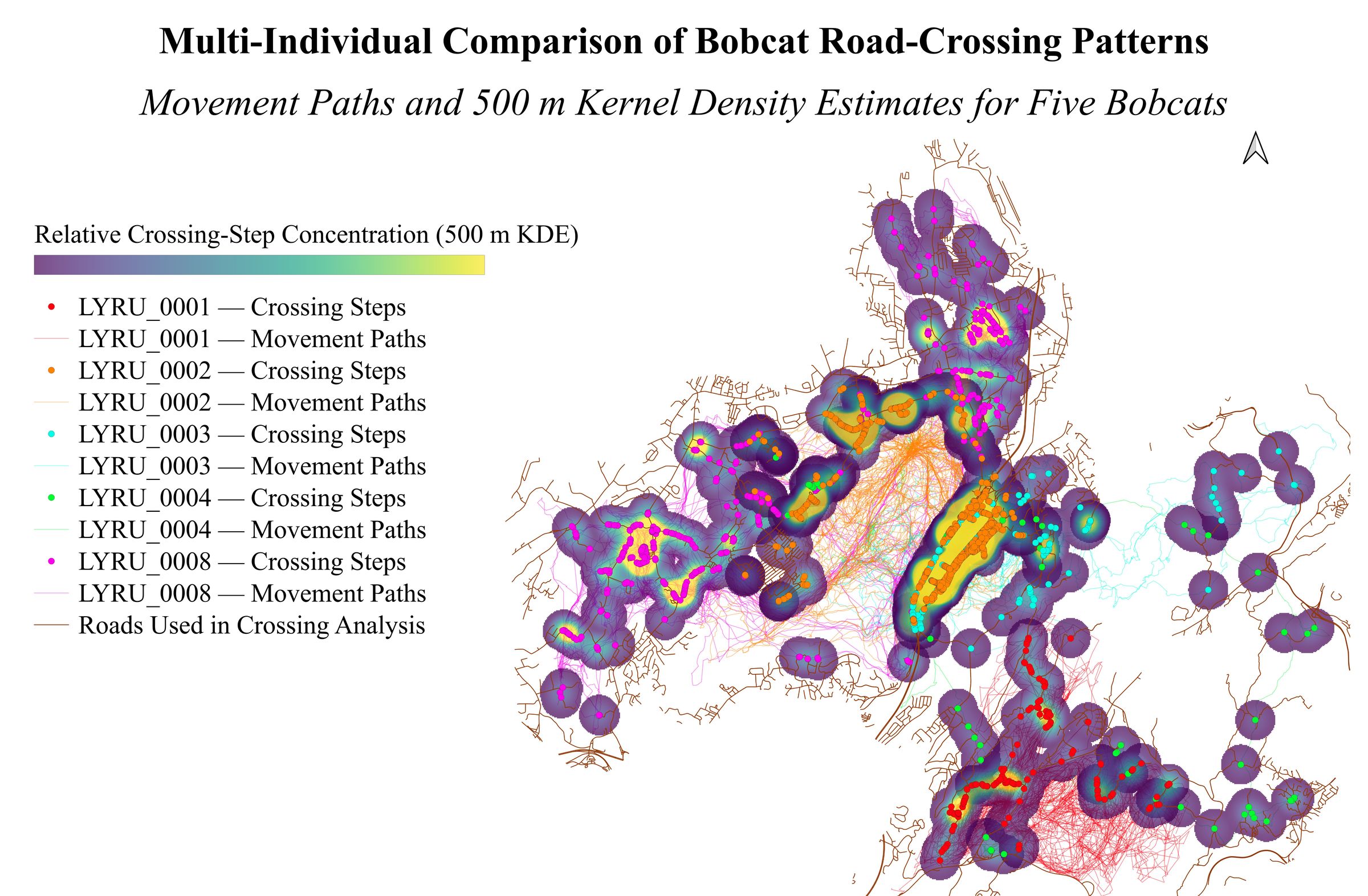
Eric’s map compares the movement paths of all five bobcats. Brighter areas mark where inferred road crossings were most concentrated.
As Eric analyzed the data, a pattern began to emerge. The inferred road-intersection locations tended to occur closer to culverts than comparison locations did. This spatial relationship suggests that culverts may influence where bobcats approach or cross roads, although GPS data alone cannot confirm that the animals actually traveled through the structures.
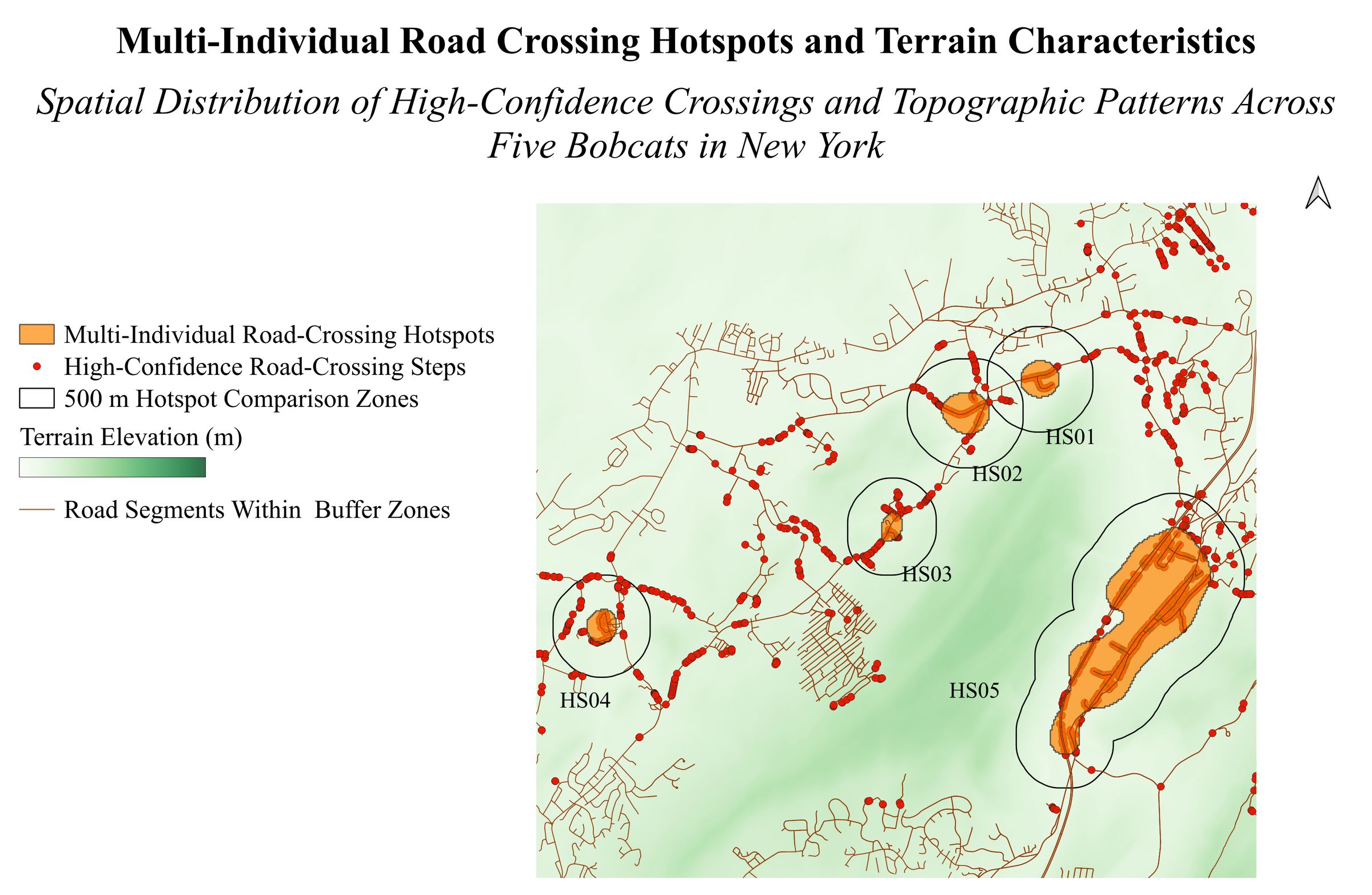
Five hotspots where multiple bobcats’ movements crossed roads. Eric found these areas were generally lower and flatter than the surrounding terrain.
“That was one of the things that stood out to me,” Eric continues. “The data showed that the bobcats were interacting with roads, and their inferred crossing locations appeared to be associated with nearby culverts.”
The finding raises another important question: How effectively do culverts and other wildlife-crossing structures help animals move safely through fragmented habitats? For Eric, it also demonstrated the importance of looking closely at data rather than simply making assumptions about how wildlife behaves.
From Biology to Independent Research
Eric is continuing to refine and analyze the data through October, with the possibility of expanding the project to include field research in the future. His project has already moved well beyond its original scope. Eric has written a research paper based on his findings and shared it with Ms. Franco and the Black Rock Forest team. He also submitted the paper to the S.-T. Yau High School Science Award competition, and later presented his research to students in Ms. Ayers’ eighth-grade science and ninth-grade English classes.

Eric says the experience has reinforced his interest in environmental science, which he hopes to study in college next fall. At Storm King, his project demonstrates how a question inspired by an everyday observation can develop into an opportunity for independent scientific research. With guidance from a teacher, access to the expertise and resources of Black Rock Forest, and real scientific data to analyze, Eric has been able to pursue the answer to a question that is important to him and to the environment.
What began with noticing wildlife along the road has become a study of the landscape itself—and of how animals find their way through it. For Eric, following the bobcats is not only about understanding where they go, but also about considering how we might build a future in which roads, communities, and wildlife can share the same landscape.
